Connection Ecology Visitory Opportunity
Boulder Open Space and Mountain Park Demonstration Project
Boulder Open Space and Mountain Park Demonstration ProjectThe initial focus of the Connection Ecology site was a demonstration project designed to show the City of Boulder Open Space and Mountain Park Department how they could apply Connection Ecology principles to its Vistor Planning efforts. This effort suggested ways in which environmental connections could be fostered. While these ideas have not been implemented, they still illustrate the kind of planning the could and should be done.
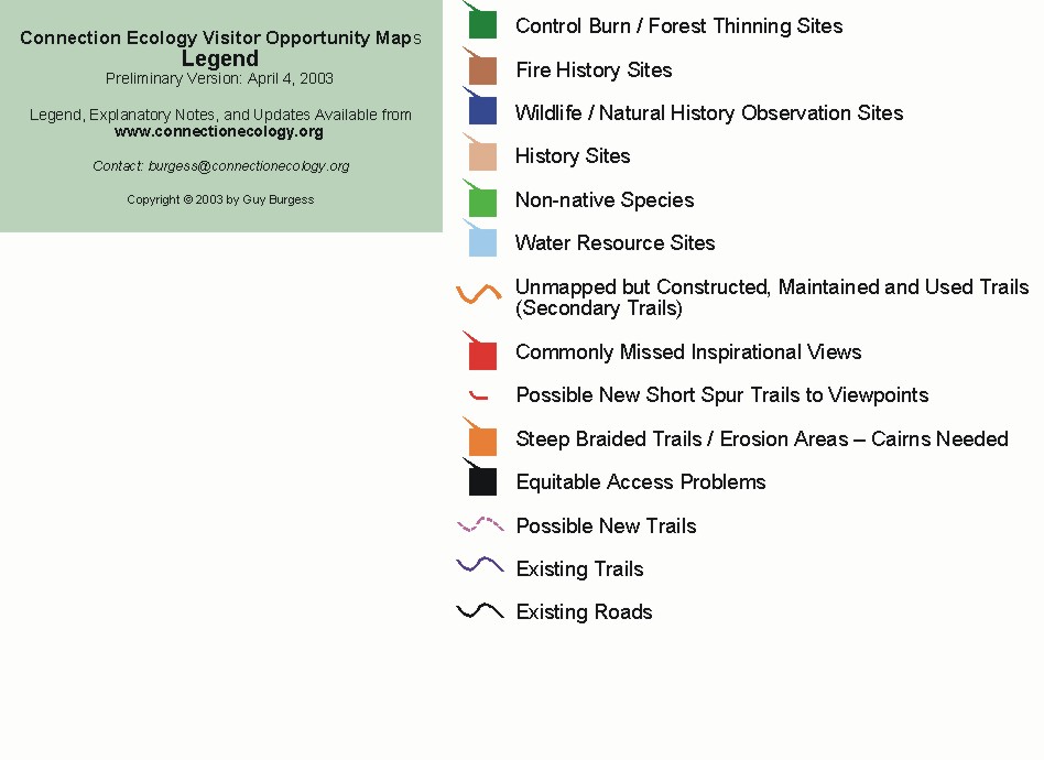
The accompanying maps can be found at this
postVisitor understanding of natural and human history he can also be developed with a series of historical "destination" hikes such as those suggested below. .
Dinosaur Sandbar / Clay Pit Along the Dakota Hogback, sometimes called "Dinosaur Ridge," east of Eldorado Mountain a series of old clay pits reveal an ancient, petrified sand bar with seemingly endless water ripple marks. This is dinosaur tracking country. A trail built along the length of these old quarries would literally give people the opportunity to track real dinosaurs. While the tracks to be found are rare and hardly of museum quality, the experience of being able to track dinosaurs in the wild is priceless.
Eldorado Railroad Before the invention of the automobile and Vail's (the highway engineer) all season highways railroads were the way people got around Colorado. For decades the elusive challenge was to find a way to penetrate the Rocky Mountains west of Denver. And, Eldorado Canyon was an important target of these efforts. Before completion of the current high-level grade which connects with the Moffat Tunnel and Winter Park, engineers for the Denver, Utah, and Pacific Railroad attempted to penetrate the Canyon with a lower-level rail line. While the project was never finished, the roadbed still exists and forms the foundation for the Fowler Trail and the upper Dowdy Draw trail. In recognition of its key part of our history and its spectacular views of Eldorado Canyon, the connection ecology maps propose reopening the connecting, center portion of the old railroad grade from Dowdy Draw to the Fowler Trail.
Water Resource Hikes Boulder residents are also almost completely unaware of the fact that, without irrigation, the valley in which they live would be almost completely devoid of trees. The history of water diversion projects is central to the history of Boulder. Few, for example, realize that Viele Lake was constructed and filled by an irrigation ditch from South Boulder Creek before there were any houses in Boulder south of Baseline Road. The abandoned irrigation ditch is a bit of history that still exists and could be highlighted on existing trails or even form the basis of a new trail from Fairview High School to South Boulder Creek.
Other key points of interest related to water development include the Denver Water Board Supply Canal, the Marshall ditch, the Silver Lake ditch, the old and now abandoned city reservoirs behind Red Rocks, the system which generates hydroelectric power from the flow the city's municipal water, and the city's numerous water tanks and reservoirs. Interpretive materials which help people understand the elaborate environmental transformations that are required to support our modern urban society should be available at these interest points.
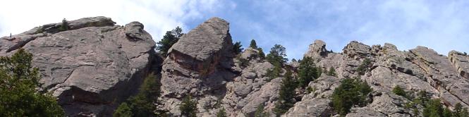
Bear Creek Natural / Human History Trail Not only does the scenic Bear Creek Trail take you through the igneous rocks that form the foundation of the Rocky Mountains. You are also able to see the geologic succession of overlying sedimentary rocks which shape so much of the area's environment. Noteworthy points of interest include the Fountain Formation which produces the Flatirons, the Lyons sandstone (found on University buildings), the Dakota / Dinosaur Ridge, and the Four-mile fault. A expert geologist could undoubtedly put together a fascinating collection of materials for visitors to this area.
The canyon's eyesore power line is also a great historical interest. Created in the early 1900s as part of one of Boulder's earliest power projects -- involving Barker reservoir, Kossler lake, and the Boulder Canyon power plant (at the tunnel). The siting of this power line away from the obvious route through downtown is reported to be one of Boulder's earliest efforts to protect its environment.
Early Settlements A lot of existing trails consist of old roads to homesteads, a few of which are still visible. Interpretive materials which tell the story of what it was like to settle these areas will also serve to deepen visitor understanding of the area's human history as would materials describing Native American habitation of the area. The connection ecology maps mark many of these cabins, along with the few surprises, like the place on the Gregory Canyon trail where you can see the ruts apparently cut into the solid rock by steel-rimmed wagon wheels.
Farming HikesOne of the consequences of our high tech society is that average citizens have lost almost all connection with the agricultural and mining activities required to support our society. One way in which the OSMP program might be able to limit this disconnect is through a series of interpretive farming and ranching programs which actively encourage people to take hiking, jogging, and biking trails which wind their way through active agricultural areas. People ought to be able to see what it takes to plant, grow, and harvest the fields of hay, corn, wheat, and, perhaps, a few vegetable crops. While this may require the redirecting of some farming activities, it could also go a long way toward demonstrating what modern, environmentally sensitive agriculture is all about. It would even be informative to include temporary closures for the application of pesticides and herbicides.
Mining Hikes The area's role as a mining center is now largely a matter of history. The adverse impacts of mineral extraction have now largely been transferred to other areas and other countries. Still, given our resource-intensive lifestyle, we ought to do what we can to highlight the long shadow cast by the area's quite limited mining activities. In addition to highlighting area coal mining in Marshall and elsewhere, the visitor plan might include a review of the area's many clay pits, and Lyons sandstone quarries. Here the extensive work required to restore the old Conda quarry is worth drawing to visitors' attention.