Sunday, March 18, 2007

Sustainable Environmentalism


The relentless growth of human settlements and the accompanying expansion into natural areas has led many in the environmental movement to view human society as something of a cancer which is growing on, and rapidly destroying, the natural environment. This way of framing the problem tends to see the environmental movement as a desperate effort to strengthen the barriers which protect the natural environment from human encroachment. In keeping with the cancer analogy, this view sees environmental protection as, quite literally, a fight for survival in which human society is the enemy. The political manifestation of this view is the contemporary conservation movement which is motivated by a philosophy which I call "separation ecology."

Unfortunately, it is an approach which fails the test of sustainability and equity. If people are increasingly separated from their environment then, sooner or later, they are likely to start asking why they should favor environmental protection measures. While alarmist (and often overstated) rhetoric about impending ecological collapse and altruistic appeals to protect natural species for their own sake may answer some of these concerns, the long-term trend is likely to be a continuing erosion of the core environmental constituency. In other words, it is unrealistic to expect to be able to sustain long-term, public support for environmental objectives if the public finds itself increasingly denied the benefits of environmental protection.

The environmental movement should also be about more than simple preservation. It has an interest in promoting human quality of life among a broad spectrum of the population, not just an elite few. It is not enough for environmental connections to be reserved for the wealthy and environmental activists who know how to take advantage of the system. The connection ecology project offers a new way of thinking about the environmental movement -- one which fosters both environmental protection and human quality of life.

Sunday, March 04, 2007

No Child Left Inside


This article appeared in The Economist on Feb 8, 2007. It summarizes the alarming fall in various measures of National Park visitation. This trend, if it continues, threatens the sustainability of the environmental movement and marks, in my view, a significant deterioration in human quality of life. A primary goal of this blog is the exploration of strategies for overcoming this problem.

Feb 8th 2007
SAN FRANCISCO
From The Economist print edition

Put down that Xbox, young man

TO THE alarm of environmentalists and park managers alike, interest in the great outdoors seems to be tailing off among young Americans. The country's extensive system of national parks includes some of the most photographed and best preserved landscapes on earth—like Yosemite Valley in California, the crenellated Teton Range in Wyoming, Old Faithful geyser in Yellowstone National Park or the white edifice of Mount Rainier in Washington state. But attendance at the parks is falling. Between 1995 and 2005, overnight stays in them declined 20% overall, and camping and backcountry stays dropped by 24%, according to statistics compiled by the National Parks Service.

No park, it seems, is immune to the decline: even in Yosemite, one of the system's oldest parks and probably its best known, the number of visitors dropped 17% over the ten-year period. The number of visitors to Death Valley, an easy drive from vigorously growing Las Vegas, went down 28% over the same span. In some of the system's remoter parks, such as Lava Beds National Monument near the California-Oregon border, site of much fighting in an Indian war of 1872-73, the number of daily visitors is down to ten or fewer.

The importance of this decline can hardly be over-estimated for big environmental organisations such as the Sierra Club: they have depended on what one expert calls “a transcendent experience in nature”, usually in childhood, to gain new members and thus remain powerful lobbyists for environmental causes. “The political implications are enormous,” says Richard Louv, a writer whose most recent book, “Last Child in the Woods: Saving Our Children from Nature-Deficit Disorder”, describes the social, psychological and even spiritual ramifications of a dearth of outdoors experience for a generation raised on electronic, rather than natural, stimulation and entertainment.

Read entire article

Thursday, March 01, 2007

Understanding the Visitor Role in the Spread of Invasive Plants: A Modest Research Proposal


Much of the OSMP management debate focuses around the threat that hikers (as well as dogs and horses) may or may not pose to efforts to control the spread of invasive species. It seems to me that there is a simple, joint fact-finding process that we could all go through to clarify this issue.

First, we need a short list of invasive species that are the posing a significant threat to Open Space. Next, we need to identify at least one location where each species is getting out of control. Over the course of a year we would then need a fact-finding team to repeatedly visit each location to determine when seeds are and are not a susceptible to human dispersal. One could also walk through each area with typical types of clothing and then examine how many of the offending seeds each person picks up. This would enable us to identify kinds of clothes that limit the collection of seeds (such as the wearing of ankle gaitors to limit “sock prickers”). We could also determine what kinds of seeds are likely to fall off on a hike and hat kinds are likely to be transported back home where they don’t pose a threat. Similar tests could be done on dogs and horses.

The resulting information could then be used to separate necessary from unnecessary restrictions.

Connection Ecology Blog Contents

Tuesday, February 20, 2007

Connection Ecology: The Next Phase of the Environmental Movement?


To date, the environmental movement has gone through three phases. The challenges of continuing population growth are now demanding that the movement enter a fourth. We call it "connection ecology." Without a move toward connection ecology, proliferating access restrictions will increasingly separate people from their natural environment, undermining human quality of life and the environmental constituency. These four phases are briefly summarized below.

Phase I: Legacy Parks (The Establishment of Yellowstone through Mission 66)
Guiding Principle: "...conserve the scenery and the natural and historic objects and the wild life therein and to provide for the enjoyment of the same in such manner and by such means as will leave them unimpaired for the enjoyment of future generations." -- The Organic Act which guides the National Park Service

Accomplishments: Yellowstone; Rocky Mountain; Arches; National Forest lands, campgrounds, and trails; Boulder Mountain Parks, etc. Today the vast majority of natural area visits are to these legacy sites. It's hard to imagine where the environmental movement would be without them.

Shortcomings: Weak understanding of complex eco-dynamics, failure to protect non-park lands, overly commercial focus.

Phase II: Outrage and Revolution (Silent Spring through the Energy Crisis)
Guiding Principle: Opposition to the widespread pillage and looting of the environment.

Accomplishments: Clean Air and Water Acts, the Environmental Protection Agency, National Environmental Policy Act, Wilderness Act, Endangered Species Act, other key environmental statutes and agencies. Defeat or pro-environmental modification of countless major projects (Glenwood Canyon, Vail Pass, oil shale, Rocky Flats, nuclear power, Marble and Bridge Canyons...)

Shortcomings: Difficulty in dealing with the "close call" environmental issues where the benefits may not outweigh the costs. The environmental movement's opposition to anything that might adversely affect the environment may have led to over-reaching and the strengthening of backlash movements (such as Wise Use).

Phase III: Hold the Line/Separation Ecology (1980/90's--present)
Guiding Principle: "Earth First. No compromise in defense of mother earth." Opposition to "industrial tourism."

Accomplishments: Expanded open space programs, wetland and endangered species protection.

Shortcomings: Undervalues human visitation. Inadequate consideration given to the costs of environmental protection. Doesn't search for visitation/protection win-win. Contributes to excessive pressure on legacy parks. Diminishes visitor experiences. Increases separation between humans and the natural environment.

Phase IV: Connection (Coexistence) Ecology (The next step, I hope)
Guiding Principles: Earth and people connected, both valued.

Accomplishments: Encourages and accommodates human visitation. Innovative, win-win visitation/protection solutions. Builds quality of life for all citizens. Builds environmental constituency.

Likely Shortcomings: Accepts some environmental risk and damage. Will require repair and restoration.

Thursday, January 11, 2007

General Principles Underlying Boulder Outdoor Coalition Trail Recommendations for Eldorado Mountain and Doudy Draw TSA


Note: This post was written at an earlier stage in the ongoing public debate over Boulder Open Space and Mountain Parks policies. While somewhat dated, the post still raises important issues which are still relevant.

1. Comparable Trail Densities — The trail densities should be somewhat lower than trail densities of comparable HCAs and Nas.

2. Equitable Treatment of User Groups — In recognition of the many different visitor constituencies within our community we believe that the trail development plan should provide "something for everyone" and should not favor some groups at the expense of others.

3. Variable Length Options — People want to spend different amount of time and travel different. distances. Quality options should range from short to long with connection to adjacent Open Space Tracts (including Jefferson County OS).

4. Fine-tuning of Trail Alignments — Our proposed trails are approximate. We expect final alignments will be determined by local conditions including such things as soil types and the need to avoid locally sensitive areas (such as nesting sites).

5. Importance of Quality Trails — As we try to limit increasingly limit visitor presence to a small number of trails, it's increasingly important of these trails be designed to maximize the visitor experience. They should deliberately seeking to identify and provide access to quality destinations including inspirational viewpoints and areas of historical or geological interest. The trails should also be constructs so that "getting there is at least half the fun" with trails designed to meet the needs of all user groupsTrails rooted for their scenic value are more desirable than those that simply follow routes of convenience (e.g. old access roads for high-voltage power lines). . Loop trails are also
widely seen as contributing as providing a more attractive user experience.

6. Visitor Restrictions — In general, environmental protection and user conflict resolution measures should employ the least restrictive method of achieving each objective. In addition, the process should be transparent with the environmental objectives and alternative strategies for achieving those objectives clearly and publically stated. The same principle should apply to efforts to address potential user conflicts.

7. Access — Parking facilities should be adequate to meet the demand. Inadequate parking which turns significant numbers of users away should be viewed and justified as a "restriction."

Sunday, January 07, 2007

Adaptive Management


It's obvious that a great deal of uncertainty exists regarding the resilience of ecosystems and the impact of various human visitation options. In the face of such uncertainty one has two basic options. One can implement an extremely cautious management plan -- one that essentially excludes visitors from an entire area. While this would obviously minimize the risks associated with human visitation, it's highly probable (but not certain) that the environmental benefits of such an approach would be quite small, at least as compared with a modest, environmentally sensitive human visitation program. Taking the most conservative approach possible would still be the obvious choice, except for the fact that there are real costs associated with unnecessary visitor restrictions. These include, for example, diminished public understanding of prairie and other ecosystems, reduced public support for open space programs, and human quality of life impacts.

It is these costs which are pressuring OSMP land managers to look for ways of simultaneously pursuing both recreational and preservation objectives. In short, they are in the politically difficult position of having to decide how cautious is too cautious.

Under such circumstances is common for the parties to wish that they knew more. Better science would reduce uncertainties in the corresponding level of needed caution. It would allow land managers allow greater visitation while simultaneously maintaining or even strengthening the level of environmental protection.

The good news is that there is a practical and inexpensive strategy for reducing uncertainty. It is based on the fundamental principle that the longer you look into the future the greater the level of uncertainty. To date the visitor planning has focused on long-term decisions with the apparent goal of crafting a series of policies which would not have to be continually reviewed. To my knowledge there was little planning and budgeting for impact monitoring and the prompt mitigation of unanticipated adverse impacts. If you're going to manage this way, you it have to have very large safety margins which, in turn, force unnecessary and controversial visitor restrictions.

An alternative, adaptive management strategy would focus more attention on short-term decisions and include funding for the continued monitoring of visitation and environmental impacts. It would have the money needed to be able to identify environmental problems as they arise and then promptly take appropriate corrective measures. It would be able to act before problems got out of hand and while mitigation options were still feasible and affordable. Similarly rewarding new visitor opportunities to be added based upon visitor suggestions and continuing environmental assessments.

For example, in areas where there are concerns that visitors might allow the seeds of invasive species to "hitchhike" on their clothing, the visitor plan could include funding a systematic search for invasive species at the earliest stages of the flowering season---when they are easily identifiable and before they've had a chance to reproduce. Any plants that are found could be destroyed and if the number of invasive plants is significantly greater than those found in the control area then a broader area closure might be implemented.

As another example, in areas where there is concern that human visitation might scare away nesting birds, the area could be closed until each year's nests are firmly established. Areas without active nests could then be reopened with the entire area opened once they the nesting season concludes. Area wide closures could then be reinstituted at the beginning of the next nesting season. An area can also be monitored for the emergence of unwanted social trails with incipient trails closed before there is significant vegetation damage.

Monday, December 25, 2006

Environmental Damage / Human Presence


Environmental damage is not the same as detectable human presence. With today's sophisticated powers of observation, we can find evidence of "damaging" human presence almost anywhere. This means that we need to be able to determine when evidence of human presence is associated with unacceptable damage and when it is merely evidence that humans are part of the ecosystem.

Monday, December 18, 2006

Environmental Constituency


Policies which build barriers which separate humans from their natural environment (something I call "separation ecology") are likely to diminish the number of people who will develop strong personal connections with the natural world. This, in turn, threatens to weaken the environmental constituency which is, in a democracy, essential to environmental preservation. Still, building environmental connections is about more than political expediency. It is about enhancing human quality of life. If environmental connections are good for people, and I believe that they are, we should try to figure out how to extend those benefits to as many people as possible. It would be tragic if an overprotective environmental movement were to confine an increasing number of people to life in which their only contact with the
natural world was through Sea World-type theme parks and nature television.

Sunday, December 17, 2006

US 36 Dispute Reveals OSMP Anti-people Bias


According to a recent Camera story, there are plans to construct a bikeway as part of the expansion of US 36 to 6 lanes. Included in the plans is a bikeway designed to give commuters an alternative to jamming the highways, filling the air with pollutants, and cultivating the couch potato physique. According to the article, the plan was to build the bikeway 30' (10 yards, 1 1st down) off a major freeway. Something to be encouraged, right? Not for OSMP. That would be an unacceptable encrouchment on open space. They're insisting that the bikers ride on the shoulder and breath the fumes (with a concret barrier). How many people do you think would do that. Where does human quality of life fit in their priorities?


Boulder Daily Camera
http://www.dailycamera.com/news/2006/dec/13/boulder-leaders-transit-officials-clash/

Boulder leaders, transit officials clash
Bike path through open space one point of contention

By Ryan Morgan (Contact)Wednesday, December 13, 2006

Boulder's elected leaders and officials planning traffic improvements for U.S. 36 clashed Tuesday night over bike paths and bus lanes.

The City Council met with Rick Pilgrim, project manager for the Environmental Impact Study along the U.S. 36 corridor, which is slated for more than $1 billion in improvements. A draft of the study — which will determine what gets built on the Turnpike once it's complete — is due to federal officials at the end of the month, and Boulder's leaders aren't happy with what it says.
The first bone of contention concerns a proposed bike path for commuters along U.S. 36. Pilgrim said an initial proposal to build a separate bike path 30 feet from U.S. 36 isn't feasible because it would run through sensitive Open Space and Mountain Parks parcels and wetlands.

That leaves two options, Pilgrim said. The path could run directly adjacent to the highway, separated from traffic by a maintenance wall. If that doesn't get approved, he said, another option would be to build on-street bike lanes on South Boulder and Cherryvale roads to take bicycle commuters around the sensitive areas.

Pilgrim said a third option, to upgrade an unpaved path that currently runs alongside South Boulder and Cherryvale roads, had been taken off the table. "After looking at this long and hard, and considering all of the details, our recommendation was to set that one aside, because it's clearly inferior," he said. But Boulder's open space and City Council officials disagreed.
"I don't know why we would do something different than take advantage of an already-existing bike path," said Mike Patton, the city's open space director. "From that standpoint, there would be very little environmental impact."

Mayor Mark Ruzzin said bicycle commuters would much prefer their own path than rubbing shoulders with traffic on a busy street like South Boulder Road. And he criticized Pilgrim and other planning officials for waiting to reveal the new options. "It leaves a bad taste in our mouths," Ruzzin said.

Council members said they're also unhappy that U.S. 36 planners are considering ending designated Bus Rapid Transit lanes at Cherryvale Road rather than at the Table Mesa Drive bus stop. City officials said the bus service depends on having its own dedicated lanes, and they worry about creating a bottleneck before the buses reach their destination.
"Clearly the idea is that we could have a very nice BRT system that works great, as long as you want to get off at Cherryvale," Ruzzin said.

Pilgrim said adding dedicated "flyover" lanes just for the buses would significantly increase the project's cost, and would only improve their travel time by 11/2 minutes, at most.
"We've not found that there is a problem with the bus leaving that lane and weaving over a lane and getting over," he said.

Wednesday, December 13, 2006

Equitable Access Problems


Fern Meadow, the Devil's Thumb Homeowners Associations virtually private City of Boulder Open Space land.

Perhaps more than anything else Boulder’s soul is embodied in its trademark Flatirons and its much loved and always busy Chautauqua Hill. In the 1970s, recognizing continuing population pressures, Boulder residents approved a tax to fund the acquisition of the rest of Boulder’s mountain backdrop and its other "Chautauqua Hills." While this effort has been a great success there are areas in which a muddled coincidence of a "preservation over visitation" environmental philosophy and the selfish desires of neighbors to limit public access to taxpayer-funded backyard playground has effectively subverted original goals of the program.

Nowhere is this more evident than in the effectively private, neighborhood-only trails in Devil’s Thumb and Eldorado Springs area. The Fern Meadow trail, for example, (south of Stoney Hill Drive) is especially problematic. This unmapped trail (which is actively being maintained with water bars) follows an old road bed and offers, for South Boulder, a view comparable the Chautauqua Hill. For years access to this area was in dispute. The Devils Thumb Homeowners Association put up fences and gates informing the public that this area of the public Open Space was only for the Homeowners Association members and guests. Alternative access points required cumbersome, boring approaches along completely unmapped and unmarked social trails.

My understanding was that the agreement between the Homeowners Association and the City resolving these access issues included the understanding that this access point (Fern Creek at Stoney Hill Drive) would either be open to the general public or closed to all. That, unfortunately, is not what has happened. There is still a gate with a sign stating that the area is private and referring visitors to a much inferior trailhead.


The gate and sign on Stoney Hill Drive.

A similar problem exists in the Eldorado Springs area where two maintained trails lead north and south in the valleys west of the Dakota Ridge. Public access to both of these is blocked by "no trespassing" or "no open space access" signs.

Monday, December 11, 2006

Research to "finds out" vs. research to "prove"


With respect to OSMP research (and most other public policy research) there is a great deal of interest in research which "proves" that what people want to believe is actually true. There is much less interest in real research -- the kind that "find outs" whether one might, in fact, be wrong. If you are serious about protecting the environment and human quality of life then we must resist the tendency to focus only on reaserch which "proves" and embrace reaserch which "finds out." We must also resist the common belief that, since there are always irreducible uncertainties it must be true that I was right all along.

Eldorado Mountain / Dowdy Draw

OSMP Board of Trustees Meeting Comments October 11, 2006
Guy Burgess

NOTE: After these comments were made, OSMP decided to retain the under the powerline alighnment and continue to deny access to the Flatirons Vista.

As someone who has made something of a career in environmental dispute resolution, I'd like to start by complimenting the Department on the process used to secure public input on the Eldorado Trail Study Area. Still, the test of environmental decision-making is not the nature public input process but the decisions that are ultimately made.

At first blush, you seem to have crafted a workable compromise. From what I've been able to gather everyone seems equally disappointed. Still, when I look at the plan I am struck by its missed opportunities.

It seems to me that the Department's mission is pretty clear. You need to find ways of equitably maximizing visitor opportunities while maintaining a high degree of environmental protection.

Key to success of such a balancing act is the active pursuit of the least restrictive way of achieving each environmental objective. Also key is the avoidance of policies which do not balance the costs of visitor restrictions with comparable environmental benefits.

Here I feel that the current plan has serious shortcomings. I'll offer a couple of examples.

First, current trail alignments strongly discourage or outright deny visitor access to the grand vistas off the north rim of the Rocky Flats Mesa (both east and west of Doudy Draw). I can't figure out how the environmental benefits these alignments could possibly justify their costs, in terms of lost visitor opportunities. Surely the Department could push the ground nesting bird protection area back 100 feet and allow visitors to enjoy the view from the rim. Similarly, it could push the least part of the Spring Brook trail out the rim.

This is the big, Flatirons vista / Dowdy Draw overlook--the best view on the whole hike. Surely they could have found an environmentally responsible way to let people see the view away from the power lines!

Flatirons Vista trail is really the access road for the power line. OSMP seems to think that, if it good enough for Public Service trucks, it's good enough for OSMP visitors.

By the same token I can't figure out what environmental benefit justifies funneling all those visitors under the high-tension power lines. Would you like to listen to the wind whistling through these power lines? Or, or would you like to listen to the birds?

There are lots of other examples:
  • Why are equestrians arbitrarily excluded from a program to evaluate the environmental impacts of off-trail visitation?

  • Why doesn't the plan take advantage of the opportunity to offer visitors a chance to literally walk along a beach visited by dinosaurs?

Correcting these oversights would be pretty simple. All it would take is the political will to move a few lines on the map and make corresponding changes to the text. The failure to make such changes would say a lot about how much you care about the quality visitor experiences.

Remember, OSMP visitors are your natural allies. How sustainable do you think the environmental movement will be if you treat them like enemies?


See Final OSMP Plan

Monday, November 13, 2006

The Original Boulder Open Space Poster


This is the poster from the original campaign to establish and fund a Greenbelt (later called Open Space) program for the City of Boulder, CO. The purpose of the program was to expand the existing Mountain Parks and to prevent development which threatened Boulder's mountain backdrop and adjacent lands.

As you can see from the poster, the vision very much included public wild land recreation.

Monday, October 30, 2006

Natural / Human History Destination Hikes


Connection Ecology Visitory Opportunity
Boulder Open Space and Mountain Park Demonstration Project

Boulder Open Space and Mountain Park Demonstration Project
The initial focus of the Connection Ecology site was a demonstration project designed to show the City of Boulder Open Space and Mountain Park Department how they could apply Connection Ecology principles to its Vistor Planning efforts. This effort suggested ways in which environmental connections could be fostered. While these ideas have not been implemented, they still illustrate the kind of planning the could and should be done.

The accompanying maps can be found at this post

Visitor understanding of natural and human history he can also be developed with a series of historical "destination" hikes such as those suggested below. .

Dinosaur Sandbar / Clay Pit Along the Dakota Hogback, sometimes called "Dinosaur Ridge," east of Eldorado Mountain a series of old clay pits reveal an ancient, petrified sand bar with seemingly endless water ripple marks. This is dinosaur tracking country. A trail built along the length of these old quarries would literally give people the opportunity to track real dinosaurs. While the tracks to be found are rare and hardly of museum quality, the experience of being able to track dinosaurs in the wild is priceless.

Eldorado Railroad Before the invention of the automobile and Vail's (the highway engineer) all season highways railroads were the way people got around Colorado. For decades the elusive challenge was to find a way to penetrate the Rocky Mountains west of Denver. And, Eldorado Canyon was an important target of these efforts. Before completion of the current high-level grade which connects with the Moffat Tunnel and Winter Park, engineers for the Denver, Utah, and Pacific Railroad attempted to penetrate the Canyon with a lower-level rail line. While the project was never finished, the roadbed still exists and forms the foundation for the Fowler Trail and the upper Dowdy Draw trail. In recognition of its key part of our history and its spectacular views of Eldorado Canyon, the connection ecology maps propose reopening the connecting, center portion of the old railroad grade from Dowdy Draw to the Fowler Trail.

Water Resource Hikes Boulder residents are also almost completely unaware of the fact that, without irrigation, the valley in which they live would be almost completely devoid of trees. The history of water diversion projects is central to the history of Boulder. Few, for example, realize that Viele Lake was constructed and filled by an irrigation ditch from South Boulder Creek before there were any houses in Boulder south of Baseline Road. The abandoned irrigation ditch is a bit of history that still exists and could be highlighted on existing trails or even form the basis of a new trail from Fairview High School to South Boulder Creek.

Other key points of interest related to water development include the Denver Water Board Supply Canal, the Marshall ditch, the Silver Lake ditch, the old and now abandoned city reservoirs behind Red Rocks, the system which generates hydroelectric power from the flow the city's municipal water, and the city's numerous water tanks and reservoirs. Interpretive materials which help people understand the elaborate environmental transformations that are required to support our modern urban society should be available at these interest points.

Bear Creek Natural / Human History Trail Not only does the scenic Bear Creek Trail take you through the igneous rocks that form the foundation of the Rocky Mountains. You are also able to see the geologic succession of overlying sedimentary rocks which shape so much of the area's environment. Noteworthy points of interest include the Fountain Formation which produces the Flatirons, the Lyons sandstone (found on University buildings), the Dakota / Dinosaur Ridge, and the Four-mile fault. A expert geologist could undoubtedly put together a fascinating collection of materials for visitors to this area.

The canyon's eyesore power line is also a great historical interest. Created in the early 1900s as part of one of Boulder's earliest power projects -- involving Barker reservoir, Kossler lake, and the Boulder Canyon power plant (at the tunnel). The siting of this power line away from the obvious route through downtown is reported to be one of Boulder's earliest efforts to protect its environment.

Early Settlements A lot of existing trails consist of old roads to homesteads, a few of which are still visible. Interpretive materials which tell the story of what it was like to settle these areas will also serve to deepen visitor understanding of the area's human history as would materials describing Native American habitation of the area. The connection ecology maps mark many of these cabins, along with the few surprises, like the place on the Gregory Canyon trail where you can see the ruts apparently cut into the solid rock by steel-rimmed wagon wheels.
Farming HikesOne of the consequences of our high tech society is that average citizens have lost almost all connection with the agricultural and mining activities required to support our society. One way in which the OSMP program might be able to limit this disconnect is through a series of interpretive farming and ranching programs which actively encourage people to take hiking, jogging, and biking trails which wind their way through active agricultural areas. People ought to be able to see what it takes to plant, grow, and harvest the fields of hay, corn, wheat, and, perhaps, a few vegetable crops. While this may require the redirecting of some farming activities, it could also go a long way toward demonstrating what modern, environmentally sensitive agriculture is all about. It would even be informative to include temporary closures for the application of pesticides and herbicides.

Mining Hikes The area's role as a mining center is now largely a matter of history. The adverse impacts of mineral extraction have now largely been transferred to other areas and other countries. Still, given our resource-intensive lifestyle, we ought to do what we can to highlight the long shadow cast by the area's quite limited mining activities. In addition to highlighting area coal mining in Marshall and elsewhere, the visitor plan might include a review of the area's many clay pits, and Lyons sandstone quarries. Here the extensive work required to restore the old Conda quarry is worth drawing to visitors' attention.

Ecology Hikes

Boulder Open Space and Mountain Park Demonstration Project
The initial focus of the Connection Ecology site was a demonstration project designed to show the City of Boulder Open Space and Mountain Park Department how they could apply Connection Ecology principles to its Vistor Planning efforts. This effort suggested ways in which environmental connections could be fostered. While these ideas have not been implemented, they still illustrate the kind of planning the could and should be done.

The accompanying maps can be found at this post.

Encouraging visitors to take ecological or "destination" hikes can do a lot to increase the sophistication of popular understanding of a broad range of issues. Suggested below are a number of possibilities.


Before and After Tours: In everyday life we are poorly equipped to observe long-term change. Our brains are attuned to motions measured in frames per second not frames per decade. Many of the visitor opportunities outlined here and in the history section involve "before and after" destination hikes. Such hikes can be created with limited signage and a few brochures (which could easily be made available at trailheads, visitor centers, and over the Web). The brochures, with accompanying historical photographs, would invite visitors to revisit the historical camera vantage points and see how things have changed. Also included would be appropriate interpretive materials explaining the science behind the changes and the resulting policy dilemmas.


Forest Ecology: Connection ecology maps mark recent fires on the front shoulder of the Second Flatiron, the north flank of the mouth of Skunk Canyon, the Bluebell/Baird trail, the area west of the Mesa Trail and south of the Maiden water tank. Also marked are forest thinning operations on Shanahan Ridge and Enchanted Mesa as well as controlled burns on Flagstaff, Enchanted Mesa, and Shanahan Ridge. There's even a small, unthinned and overgrown forest on Shanahan Ridge with densely packed but stunted trees. Finally, there are disease kills on the West Ridge trails of both Bear Peak and Green Mountain and on the North Face of the Green Mountain Summit cone.

Non-native Species: A second complex ecological issue facing the parks which is invisible to the casual observer involves the invasion of various non-native species. In some cases the invasions involve relatively stable populations of species deliberately introduced by humans wishing to enhance the environment with, for example, apple trees and wildflowers. Other invasions, such as the many different kinds of thistle are, however, quite capable of overrunning existing populations and significantly harming the environment. Informative fliers would guide people to places where they can witness the process of ecological invasion and make their own, more informed, judgments about what control measures are appropriate. Connection ecology maps highlight apple and oak tree locations in Gregory Canyon and sweet peas on Chautauqua Hill and thistle infestations on Flagstaff and Shanahan Ridge. OSMP staff could certainly identify additional areas where non-native species problems can be observed.

Wildlife Observation Blinds: Large sections of mountain parkland (including the popular rock climbing areas of the Amphitheater and the Third Flatiron) are now closed much of the year to protect nesting raptors. In order to build public understanding of these beautiful birds and the role that they play in the ecosystem, the connection ecology program would construct short spurs from existing trails to raptor observation points where people could unobtrusively observe the birds as well as review appropriate interpretive materials. Here the map suggests a Bluebell Canyon overlook spur from the Royal Arch Trail.

Seasonal Variations Hikes: One advantage of the Web and the system's many on trail bulletin boards is the ability to post a broad range of seasonal interpretive materials. It should not be very expensive to post continually changing "what you can see this month" bulletins highlighting things like blooming wildflowers, pine tree pollination season, migrating birds, and seasonal animal behavior.

Wednesday, October 25, 2006

Inspirational Viewpoints


Boulder Open Space and Mountain Park Demonstration Project
The initial focus of the Connection Ecology site was a demonstration project designed to show the City of Boulder Open Space and Mountain Park Department how they could apply Connection Ecology principles to its Vistor Planning efforts. This effort suggested ways in which environmental connections could be fostered. While these ideas have not been implemented, they still illustrate the kind of planning the could and should be done.

The accompanying maps can be found at this post


For many visitors, the most rewarding part of their open space visit is time spent relaxing at one of the area's truly inspiring viewpoints. Given the importance of these views and the general shortage of places to enjoy them apart from the bustle of the busy trail, the connection ecology maps highlight a number of commonly missed, but spectacular viewpoints which can be reached by short spur trails. Among viewpoints marked on the maps are the following.

Eldorado Mountain and Bear Peak Among the viewpoints highlighted is a view of Eldorado Canyon from the old railroad grade (assuming that access to a trail following this grade is approved--see history hike page). Another viewpoint (and this is the last one that requires the formal acceptance of significant new trail segments ascends to the summit of Dakota Ridge on a prominent social trail from the saddle between Eldorado Springs and Shadow Canyon. Another key viewpoint is found on the west end of the mesa which separates the Towhee trail from the South Mesa trail. Shadow Canyon hikers who commonly experience an endless walk through the trees could benefit from a short spur to a spectacular viewpoint at the base of the large boulderfield below the Devil's Thumb. Currently, the old microwave tower trail stops a few feet short of a spectacular viewpoint on the crest of the Dakota Ridge southwest of NCAR. Another highlighted viewpoint avoids the riparian area along Bear Creek while still providing easy access to one of the Mountain Park's few waterfalls (in the late spring only).

Green Mountain Given the short supply of uncrowded viewpoints at the top of Green Mountain, the connection ecology map notes that a short trail connecting the two west ends of the switchbacks just before the summit of the Greenman trail would take visitors to a rocky outcropping with a spectacular view of the Indian Peaks. Three other exceptional views in this busy area are also marked. One follows a short spur from the West Ridge Trail to one of the many hills overlooking Long and Panther canyons. An even more spectacular viewpoint can be reached from the short scramble onto the rocks at the end of the last major switchback on the Ranger trail (before the junction with the West Ridge Trail). Yet another viewpoint gives visitors an opportunity to look down on the Flatirons from a few feet off the Greenman trail where it first approaches the crest of the Saddle Rock ridge. There are also numerous viewpoints on the unmapped climber access trails around the Flatirons including one in the boulderfield separating the Second and Third Flatirons, another at the back of the Third Flatiron, the First Flatironette, and three major viewpoints on the First / Second Flatiron trail (one of which actually takes hikers to the middle of the Flatirons and a view normally reserved for rock climbers only).

Flagstaff / Redrocks Area The Connection Ecology maps also recognize great views at the end of a short spur off the Flagstaff trail to the top of Campbell's cliffs and another viewpoint to the southeast of Alamo Rock. West of Red Rocks there are great views from the east end of the "pipeline" road and at the west end of Anemone ridge (at the OSMP boundary).
General CommentsThese are only some of the suggested viewpoints. The careful review of the connection ecology maps will find more. While I have not marked the many inspirational views accessible from existing trails, inclusion of information about these viewpoints would help people plan more rewarding hikes. These places can all be made a bit more enjoyable with a little discrete reworking of area rocks and wants to provide informal and comfortable places to sit.

Friday, October 20, 2006

Natural / Human History Destination Hikes


Boulder Open Space and Mountain Park Demonstration Project

Natural / Human History Destination Hikes
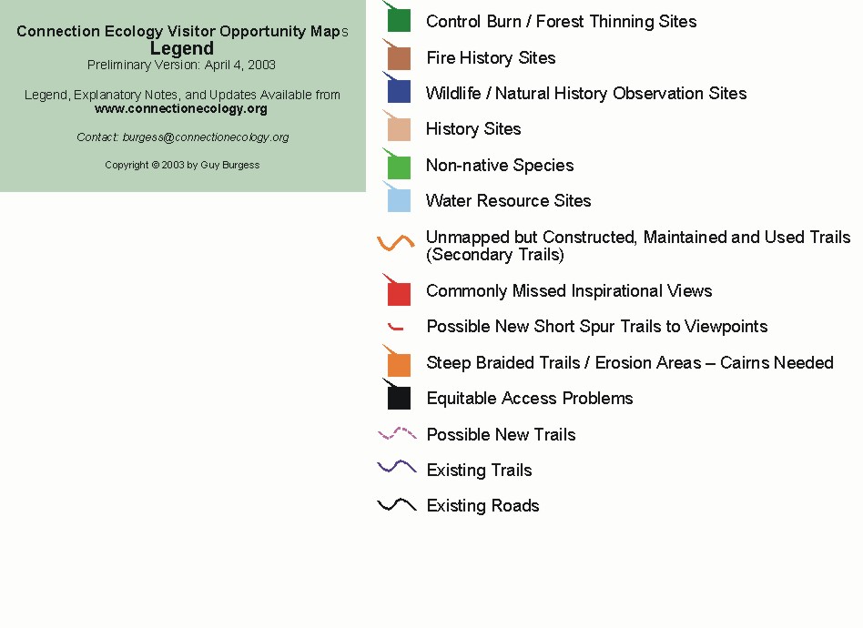
NOTE: Many of the destination hikes described on this page are marked on the connection ecology maps. Consult the legend for a key to the symbols.


Visitor understanding of natural and human history he can also be developed with a series of historical "destination" hikes such as those suggested below. .


Dinosaur Sandbar / Clay Pit Along the Dakota Hogback, sometimes called "Dinosaur Ridge," east of Eldorado Mountain a series of old clay pits reveal an ancient, petrified sand bar with seemingly endless water ripple marks. This is dinosaur tracking country. A trail built along the length of these old quarries would literally give people the opportunity to track real dinosaurs. While the tracks to be found are rare and hardly of museum quality, the experience of being able to track dinosaurs in the wild is priceless.


Eldorado Railroad Before the invention of the automobile and Vail's (the highway engineer) all season highways railroads were the way people got around Colorado. For decades the elusive challenge was to find a way to penetrate the Rocky Mountains west of Denver. And, Eldorado Canyon was an important target of these efforts. Before completion of the current high-level grade which connects with the Moffat Tunnel and Winter Park, engineers for the Denver, Utah, and Pacific Railroad attempted to penetrate the Canyon with a lower-level rail line. While the project was never finished, the roadbed still exists and forms the foundation for the Fowler Trail and the upper Dowdy Draw trail. In recognition of its key part of our history and its spectacular views of Eldorado Canyon, the connection ecology maps propose reopening the connecting, center portion of the old railroad grade from Dowdy Draw to the Fowler Trail.


Water Resource Hikes Boulder residents are also almost completely unaware of the fact that, without irrigation, the valley in which they live would be almost completely devoid of trees. The history of water diversion projects is central to the history of Boulder. Few, for example, realize that Viele Lake was constructed and filled by an irrigation ditch from South Boulder Creek before there were any houses in Boulder south of Baseline Road. The abandoned irrigation ditch is a bit of history that still exists and could be highlighted on existing trails or even form the basis of a new trail from Fairview High School to South Boulder Creek.


Other key points of interest related to water development include the Denver Water Board Supply Canal, the Marshall ditch, the Silver Lake ditch, the old and now abandoned city reservoirs behind Red Rocks, the system which generates hydroelectric power from the flow the city's municipal water, and the city's numerous water tanks and reservoirs. Interpretive materials which help people understand the elaborate environmental transformations that are required to support our modern urban society should be available at these interest points.


Bear Creek Natural / Human History Trail Not only does the scenic Bear Creek Trail take you through the igneous rocks that form the foundation of the Rocky Mountains. You are also able to see the geologic succession of overlying sedimentary rocks which shape so much of the area's environment. Noteworthy points of interest include the Fountain Formation which produces the Flatirons, the Lyons sandstone (found on University buildings), the Dakota / Dinosaur Ridge, and the Four-mile fault. A expert geologist could undoubtedly put together a fascinating collection of materials for visitors to this area.


The canyon's eyesore power line is also a great historical interest. Created in the early 1900s as part of one of Boulder's earliest power projects -- involving Barker reservoir, Kossler lake, and the Boulder Canyon power plant (at the tunnel). The siting of this power line away from the obvious route through downtown is reported to be one of Boulder's earliest efforts to protect its environment.


Early Settlements A lot of existing trails consist of old roads to homesteads, a few of which are still visible. Interpretive materials which tell the story of what it was like to settle these areas will also serve to deepen visitor understanding of the area's human history as would materials describing Native American habitation of the area. The connection ecology maps mark many of these cabins, along with the few surprises, like the place on the Gregory Canyon trail where you can see the ruts apparently cut into the solid rock by steel-rimmed wagon wheels.


Farming Hikes One of the consequences of our high tech society is that average citizens have lost almost all connection with the agricultural and mining activities required to support our society. One way in which the OSMP program might be able to limit this disconnect is through a series of interpretive farming and ranching programs which actively encourage people to take hiking, jogging, and biking trails which wind their way through active agricultural areas. People ought to be able to see what it takes to plant, grow, and harvest the fields of hay, corn, wheat, and, perhaps, a few vegetable crops. While this may require the redirecting of some farming activities, it could also go a long way toward demonstrating what modern, environmentally sensitive agriculture is all about. It would even be informative to include temporary closures for the application of pesticides and herbicides.

Mining Hikes The area's role as a mining center is now largely a matter of history. The adverse impacts of mineral extraction have now largely been transferred to other areas and other countries. Still, given our resource-intensive lifestyle, we ought to do what we can to highlight the long shadow cast by the area's quite limited mining activities. In addition to highlighting area coal mining in Marshall and elsewhere, the visitor plan might include a review of the area's many clay pits, and Lyons sandstone quarries. Here the extensive work required to restore the old Conda quarry is worth drawing to visitors' attention.
Tuesday, October 10, 2006

Demonstration Project Maps / Legend


Boulder Open Space and Mountain Park Demonstration Project
The initial focus of the Connection Ecology site was a demonstration project designed to show the City of Boulder Open Space and Mountain Park Department how they could apply Connection Ecology principles to its Vistor Planning efforts. This effort produced the following maps suggesting ways in which environmental connections could be fostered. While these ideas have not been implemented, they still illustrate the kind of planning the could and should be done.

Commentary accompanying these maps is found on the following posts:

Ecology Hikes
Natural / Human History Hikes
Inspirational Viewpoints

Legend


Flagstaff

Green Mountain

Bear Peak

Eldorado Mountain

Sunday, October 01, 2006

Proposed Marshall Mesa Interpretive Trail


Guy Burgess

Note: This post was written at an earlier stage in the ongoing public debate over Boulder Open Space and Mountain Parks policies. While somewhat dated, the post still raises important issues which are still relevant.

Among urban environmentalists and wilderness recreationists, the least well understood local ecosystem is the prairie. Seldom appreciated as a vibrant ecosystem, it is commonly seen as little more than vacant land – a place where any human use is preferable to leaving the land the way it was. From metro Denver you have to drive a very long way – perhaps of the Pawnee National Grasslands to get a sense of what the prairie was like before the great waves of farming, ranching, urbanization, and accompanying irrigation. At Marshall Mesa have a rare opportunity to change that with construction of an interpretive "prairie appreciation" trail.

While I don't know the area well enough to propose a specific alignment, I do think that you need something with the following characteristics. First, and in keeping with the area's designation as a Habitat Conservation Area, I see this as an on-trail-only trail with a double fence, "cattle chute" design in particularly sensitive areas. It would be an out-and-back trail that would, because it provides access to sensitive areas, be closed to cyclists and equestrians. (Hitching posts and bike racks could be available at the trailhead.) The design could also include spurs that would be closed during the nesting season and other environmentally sensitive times.

The alignment would follow an unobtrusive and wandering route that would tour the different types of grasslands, riparian zones, big views, and wildlife observation areas. Where appropriate wildlife observation blinds and shaded benches could be built. Interpretive materials could be keyed to numbered posts and accompanying interpretive pamphlet which could be distributed at the trailhead and made available online. There might also be a short and long versions of the pamphlet for visitors with differing levels of interest. Also available would be bird lists, plant identification guides, historical descriptions, and explanations of applicable agricultural practices. The exact length of the trail would depend upon the geographic distribution of points of interest (though something around a mile and a half would probably work). You want to get people to the point where they can experience the sights and sounds of the prairie without interference from adjacent urban areas.

With good planning you should be able to build public support for prairie preservation while simultaneously protecting the area's sensitive environmental resources.